Diamonds in the Canadian Shield
In any Archean setting, kimberlite pipes of many geo-electric descriptions will be found in a wide range of topographic settings.
Such variety calls for a full-spectrum, high-resolution, true 3D imaging capability to maximize exploration drilling effectiveness.
While 3D E-SCAN has yet to be applied for this resource, performance elsewhere indicates that 3D E-SCAN should be able to resolve any kimberlite pipes that show a geo-electric distinction against host rocks, in any field conditions. This would include conditions of conductive cover, resolving resistive-, conductive-, or complex-signature pipes on land or under lakes.
E-SCAN 3D may be the appropriate tool for mapping the newly recognized class of pipes that remains undetected through conventional EM, magnetic and gravity surveys,- E-SCAN 3D maps rock characteristics that are not easily resolved by any of those three methods. Examples of these difficulties are seen in the hidden, non-reactive pipes that have been discovered (by condemnation drilling or other excavation) adjacent to conventionally-detectable pipes.
3D model results below show the 3D mesh resolution that would be used for imaging three difficult-to-map pipe signatures, including confirming the absence of a pipe. Whether the airborne anomaly is magnetic or electro-magnetic, the E-SCAN 3D follow-up approach is the same.
Setting # 1 Conductive pipe.
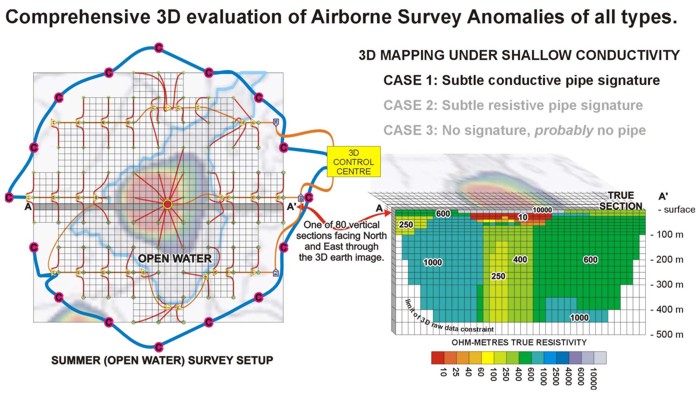
If surveyed in winter, electrodes would be dropped through the ice to the bottom mud.
In summer, electrodes are dropped into the mud from a GPS-guided canoe or inflatable watercraft, and wired
to a central floating switch, as shown in the diagrams below.
Either way, setup is fast, with wiring and electrodes ready to shoot full 3D in less than 2 days on site. Full 3D
acquisition, cleanup and exit in less than a week per anomaly site. Sites can be leapfrog-prepped for 3D mapping of one site every 2 days,
to cover a large number of evaluations in a single season or single mobilization event.
Reliably subtle full-spectrum imaging is the hallmark of 3D E-SCAN, employing the thousands of multi-directional raw-data measurements to generate its CAT-scan-like 3D image resolution.
Setting # 2 Resistive pipe.
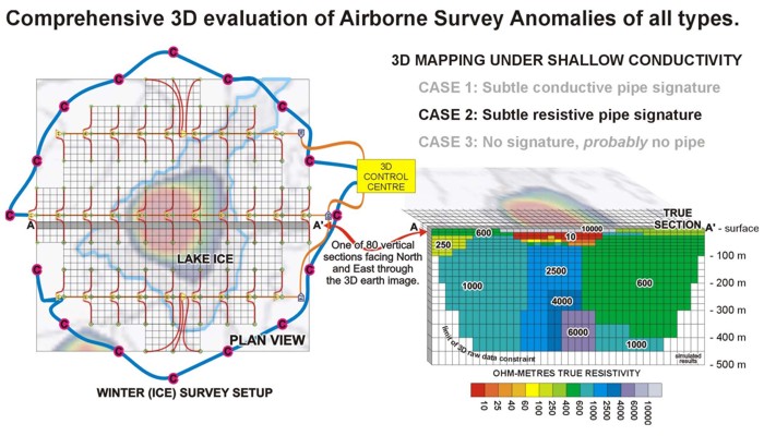
Experienced geophysicists will appreciate the ability to resolve resistive features beneath extremely conductive (and variable ) cover, as above. Resolution like this is only available with the type of raw data set generated by E-SCAN 3D. For a real-world example of mapping resistive features under conductive cover, check out the Paradise Peak results under Epithermal Gold section.
Setting # 3 No pipe.
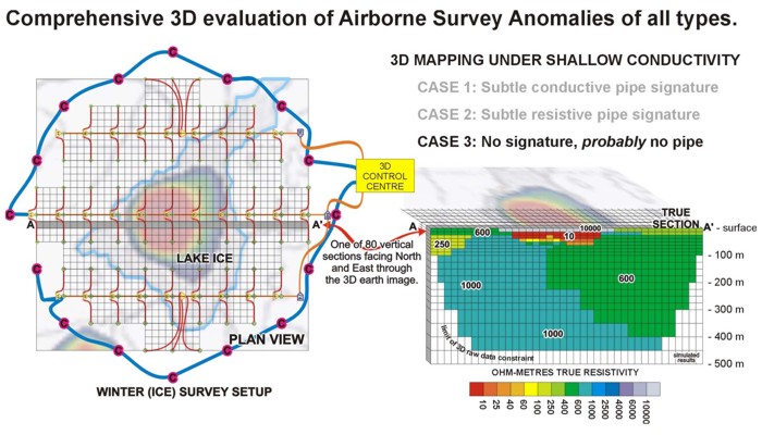
Knowing that there is no subsurface pattern suggestive of a pipe structure enables the explorationist to confidently pack up and move on to the next anomaly site. When the full set of 25 plan view elevations, 40 vertical sections facing North and 40 more vertical sections facing East are examined, a pattern of normal faulting with crossbreaking structure, may visibly explain the cause of the depression hosting the pond.
Detecting adjacent hidden pipes
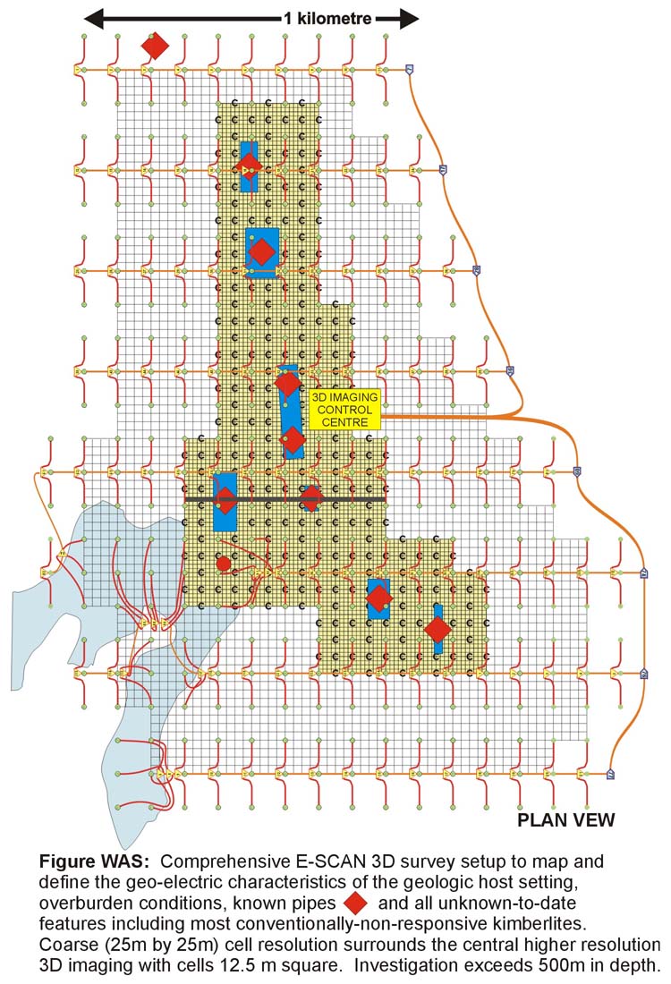
3D mapping of an entire cluster system might reveal previously undetected nearby pipes, early in the project. Anomaly views will be similar to those shown above, with more geologic and structural context available from wider survey coverage. At right is a typical field setup covering 4 square Km, with summer open-water wiring, shown over a typical northern Quebec setting.