Playas
The extreme evaporite-caused conductivity of a typical playa
is routinely managed by 3D E-SCAN field technology.


to E-SCAN HOME PAGE

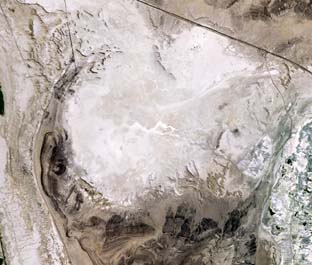
Left   A playa covers a square mile of a 3D E-SCAN survey area in Nevada. By choosing an appropriate time of year for the survey, the difficulties presented by wet, muddy surface conditions can be minimized, ensuring easier movement of project ATVs and equipment.

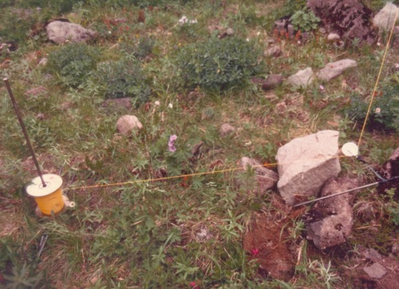
Where a playa remains wet or muddy year-round, other measures may be needed, including treating the area like a lake and installing the primary wiring system around the perimeter, with interior electrode stations wired by whatever means works in the local conditions. 
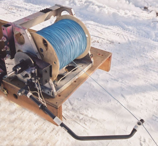
As with any E-SCAN survey, the difficult electrode station sites need to be accessed just once at the start... after that the entire survey is shot to full True 3D standards without anyone having to venture back into that area. Following survey completion, the wire and electrodes are recovered in only the second foray into the muddy conditions. This is a major operating advantage for E-SCAN, in these or any difficult conditions. It ensures that surface conditions don't dictate your exploration strategy... you get continuous 3D imagery where you need it, not just where you can get it.

Valley-bottom hot springs can create conditions worse than a playa, staying wet all year round, and including non-obvious traps of spongy or unstable soils that make mechanized travel hazardous.

Playa conditions usually present electrical problems. Strong inherent conductivity (wet, salty conditions) distorts introduced current flow, channelling much of it laterally instead of down. This can seriously compromise any method that does not have the ability to accurately map the conductive layer geometry and incorporate it as part of the geo-electric earth model. 3D E-SCAN does this, so current flow distortions are mapped and understood, allowing the important conditions deeper below, in the exploration target areas, to be accurately mapped and imaged.

All of this presumes that there is enough signal left at these depths, after lateral current flow distortion. 3D E-SCAN's comprehensive suite of advantages again prevails: the pole-pole array's very large signal advantage (compared to conventional array surveys) delivers useable signal levels even in generally conductive deeper conditions.

In summary, a playa tests many aspects of operating efficiency, data/signal performance, and interpretation capabilities, of which conventional surveys tend to fail on all aspects. 3D E-SCAN considers a playa situation as just another operating setting, fully manageable in the past, fully manageable in the future. The property-wide survey maintains perfect continuity in the true 3D field data set (uniform distribution, high density, high signal, and multi-directional data set characteristics) on approach, through, and past the other side of the playa conditions, as if the playa wasn't there.     Time, cost, risk?

                For further explanation and illustrations see the "TECHNICAL BACKUP" link.

True 3D geo-electric models
      "True 3D" refers to a comprehensively hard-data-supported 3D inversion model, whose objectivity is secured provision of a genuinely 3D raw data set, one that is rigidly defined as (1) dense, (2) uniformly distributed, (3) all-directional, (4) consistently over-deep measured data, with inherent characteristics sufficient for the (5) objective recognition and correction (or elimination) of questionable data.

      Using the complete set of appropriately positioned and oriented raw data values, the True 3D process can actively define and constrain every part of the entire 3D earth model, including "uninteresting" background areas. Virtually no earth model aspect is left to the infill interpolation, extrapolation, smoothing or other programmed estimations that most inversion algorithms must employ to ensure a 3D model result through areas represented by sparse or incomplete raw data.
      It follows that, for an all-encompassing (True 3D data-based) survey, there can be no possibility of an initial conceptual error in survey parameterization (pre-survey choice of survey line orientation, depth estimate, model type estimate) because no such pre-survey guesswork is required. No pre-survey parameter selection is ever needed... 3D E-SCAN samples all parameters, every time.

      Non "True 3D", by this definition, would be those "3D-looking" earth models that:

    a) are directly 3D-inverted by a 3D algorithm using non-3D raw data, e.g. sparse, single- or non-directional in orientation, or having insufficiently deep raw data, at least one of which characteristics results from any line-type DC resistivity survey array and almost all EM methods,    or

    b) are cobbled together from 1D profiles or 2D sections, arithmetically merged or graphically stitched, based on the questionable assumption that an objective 3D model can be obtained from some number of adjacent 2D sections or 1D stacks.
When all other attempts fail, and the playa area remains critical to understanding the broader
area geo-electric regime, one can always resort to helicopter placement of stainless steel
electrodes at the GPS indicated sites.     E-SCAN has experience in remote helicopter-assisted
electrode placement in "impossible access" areas.     Auto-braked wire dispensers maintain
control as a simple tank-trap electrode (3 electrodes arranged like the 3 axes of a cube) is
lifted toward the site, then dropped. Recovery with a hook is applied, or if the electrode has
sunk out of sight, it may be permissible to recover just the wire by pulling from the edge of
the playa (thus requiring no return visit from the helicopter).

Below, the auto-braking mechanism on this wire dispenser allows wire to be
erratically pulled at up to 30-40 miles per hour, with no risk of backlash.

Improvisation can be done with whatever is available, provided the arrangement is
rehearsed and approved in advance by the helicopter pilot (below, at Mt. Makushin, AK.

A small portion of a grid that encounters playa conditions generally is not significantly slowed. However, planning for a survey area that is dominated by wet desert playa conditions would be costed at a premium to reflect the anticipated extra time and equipment to handle the wet conditions. By "wet conditions", we mean impassible by ATV, and difficult or dangerous on foot.

Time:     In the playa areas, negligible to twice the time required.
Cost:     Up to 50% premium for areas known in advance to present severe difficulties.
Data processing:     no changes, provided field data are acquired throughout the playa area.
Risk to client:     low to zero, - eligible for guaranteed cost treatment.